We all look up at the sky every day. But how many of us know what the clouds can tell us about weather? If you’re out on a hike or happen to be stranded somewhere, what is going on above you can help you predict what your next moves should be.
Clouds are given different names based on their shape and how high up in the sky they are. The basic cloud types are cirrus, cumulus, nimbus and stratus. Clouds in the (roughly) middle of the sky are called alto- clouds. All together, there are about 100 cloud types based on combinations of these and some other descriptive names.
Most of us probably know what rain clouds look like. But what’s the difference between cirrus and altocumulus? And what can their appearance tell us about what weather is coming around the corner?
Let’s take this cloud quiz and find out. Below are photos of 10 cloud types. with a list of the 10 names below it to choose from. Write down your guess for the type of cloud shown in the images and their associated weather. Then scroll down below the photos for the answers.


List of Cloud types
1. Cirrus
2. Stratocumulus
3. Altostratus
4. Cumulus
5. Lenticular
6. Cirrocumulus
7. Nimbostratus
8. Asperatus
9. Altocumulus
10. Cumulonimbus
There are 10 basic classifications of clouds:
• High clouds: Cirrus, Cirrocumulus and Cirrostratus
• Middle clouds: Altocumulus, Altostratus and Nimbostratus
• Low clouds: Stratocumulus, Stratus, Cumulus and Cumulonimbus
Working from left to right across each row, here are the answers:
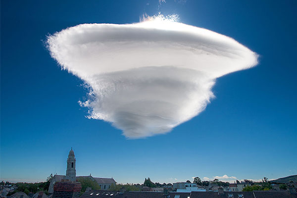
Row 1. Left – Lenticular
This photo was taken over Northern Ireland. These clouds are somewhat rare and are called lenticular because of their flat shape, like a lens. They only occur where large objects such as mountains or sometimes very tall buildings or bridges disrupt the flow of air over the surface of the earth. Therefore people who live in geographically flat areas likely will never see one. Sometimes they look like UFOs and have been mistaken for such, especially among people who did not realize that clouds can take saucer shapes. They form under very specific conditions when moist air flows horizontally and then moves up and down over the mountains or other structures. They form in the moist layers of rising air. Weather-wise, they don’t cause problems unless you are a pilot or paraglider. If they grow large enough they can produce precipitation but generally they are just an indicator of air turbulence.
Right – 2. Asperitas
This is sort of a trick questions, because until recently, these clouds did not have their own name. Back in May 2017, a new cloud type was added to the International Cloud Atlas for the first time in 30 years. It’s called an asperitas cloud, and I think you should consider yourself lucky if you see one of these cool but rare shapes. The asperitas cloud is a type of roll cloud that means “roughness.” They got their name because they look sort of like waves on a choppy sea. These clouds look dark and stormy but almost always dissipate without producing severe weather.
Row 2. Left – Cirrus
Cirrus clouds are high up in the sky and are thin and wispy. They often look like “horse’s tails.” Don’t worry if you just see a few random cirrus clouds. If there are a large number of cirrus clouds in the sky, that is an indication that there is a warm front approaching. In this case, stormy weather is on the way. After the cirrus clouds appear, the next band of clouds will be the rain clouds. When cirrus clouds appear in front of a cold front, it is because the upper atmosphere is so windy that the sirrus were blown off larger rain-bearing clouds and rain and high wind is on the way.
Right – Stratocumulus
These are large, dark, rounded clouds that appear at lower atmospheres. They can’t get taller because dry, stable air is above them, preventing them from moving upwards. Most often, stratocumulus produces no precipitation or when they do, it is light rain or snow. However, if weather has been mild and then they appear, it means stormier and windier weather is on the way. If the weather has been story and then they appear, it means that the weather is likely improving soon.
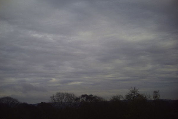
Row 3. Left – Nimbostratus
The nimbus clouds are all rain bearing, so it is a good idea to learn to recognize these types if you’re going to be away from shelter for long. They are low-forming clouds that are dark and don’t have very many features. They are mostly just masses of vapor. Nimbostratus is not associated with thunderstorms, but it does predict steady rain that could grow more forceful. If the clouds don’t move away from the area, the rain could persist for several days.
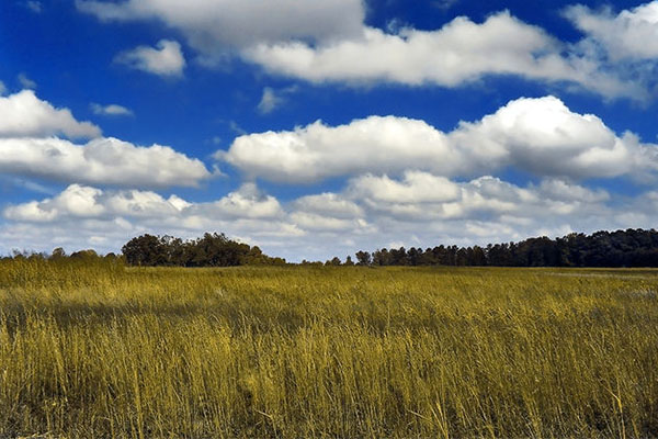
Right – Cumulus
Cumulus means “heap” or “pile” in Latin. It’s where we get the word “accumulate.” These clouds are “heaps” of fluffy, cotton ball-like vapor that is usually flat on the bottom, so that to me is an easy way to remember this cloud formation. They may appear by themselves or with other clouds, or in distinct rows and patterns. Cumulus clouds form low in the sky and are often formed in front of other cloud formations that follow them. If cumulus begin to stick together and grow upwards, they can form rain-bearing clouds but they generally do not produce precipitation on their own. By themselves, they indicate fair weather.
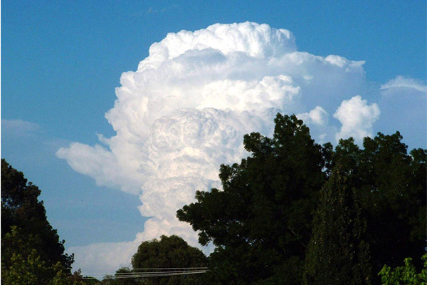
Row 4 Left – Cumulonimbus
As mentioned before, nimbus clouds are always rain bearing and cumulus are “heaps” of puffy cottony clouds. So these are tall, towering clouds with a puffy appearance that always means rain. When you see these during storms they may have that classic “anvil” shaped” thunderhead appearance. These clouds can and often do produce lightning and can even turn into tornadoes. The picture shown is a subtype called a cumulonimbus calvus. The cloud consists mainly of water droplets. Since it is so tall, water at its top may turn into ice crystals as the cloud grows. As more water droplets turn into ice at the top of the cloud, the top is still puffy but the outlines of the cloud become less sharp. When there are a lot of these ice crystals, these clouds can produce hail.
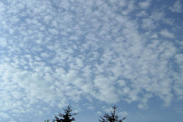
Right – Cirrocumulus
This is another example of the cumulus “heap” clouds and is also one of the most common. These clouds look like individual cotton balls placed seemingly randomly or in rows along the sky. These are high-altitude clouds that contain only a small amount of water droplets that may have already turned into ice because the clouds are so high up in the sky. These clouds can sometimes produce rain high up in the atmosphere that may never actually fall to earth. Cirrocumulus are often transition clouds and appear at the beginning and end of a weather pattern that is changing. If the Cumulonimbus cloud as described above starts to break apart, these clouds can be seen, which probably means the weather is improving.
If these clouds form along with cirrus or cirrostratus (a high level, thin cloud of ice that often causes a halo around the sun or moon) that means rain is coming in 8 to 10 hours or possibly longer depending on the wind speed. If the only clouds are patches of cirricumulus by itself and it has been stormy already, it means that the weather is improving. As long as no other clouds move in, the good weather should stick around for a while.
Row 5 Left – Altostratus
This photo shown is actually a subtype of altostratus called altostratus undulatus. The strat- part of the name means the clouds form in sheets or layers. They are usually features, low clouds but the undulatus type cane be wavy. Often, the altostratus becomes nimbostratus, and that means rain is on the way soon. If they form along with icy cumulonimbus, it can mean that a snowstorm is in the near future.
Right – Altocumulus
As we said before, cumulus are very common clouds and there are many subtypes of these clouds. Cirrocumulus are white, like cotton balls. Altocumulus is a mix of water and ice and they can look more gray. Alto means these clouds form high up in the atmosphere. These clouds are what sometimes look like “fish scales” in the sky. These “mackerel skies” are the subject of weather poems like “Mackerel sky, mackerel sky. Never long wet and never long dry.” When mackerel clouds move in, rain is six to 12 hours away. For altocumulus in general, these clouds on their own rarely produce rain unless it is high up in the atmosphere and doesn’t make it to earth.
Hopefully you enjoyed this cloud quiz! Next time you’re on a hike or camping, or even just sitting on your back deck, look up. You may be able to figure out whether you should plan that cookout for tomorrow or wait a few more days.